Posted August 21, 2008
New interactive map making feature at MPIP
|
Have you ever wanted to compare the amount spent per pupil across school districts in the Philadelphia area, find out the number of Superfund or Hazardous Waste Sites near you or how much funding for arts and culture each county receives from state and federal government sources? |
|
|
Now, thanks to MetroPhilaMapper, a new interactive mapping capacity on the web site of Temple University’s Metropolitan Philadelphia Indicators Project, this information and more is just a few clicks away. Funded by the William Penn Foundation, MPIP promotes regional thinking about metropolitan Philadelphia’s most important challenges by illuminating conditions and trends in the nine-county region (defined as the central cities of Philadelphia and Camden along with the Pennsylvania counties of Bucks, Chester, Delaware and Montgomery, and the New Jersey counties of Burlington, Camden, Gloucester and Salem). Since 2003, The Metropolitan Philadelphia Indicators Project has collected, updated, analyzed and mapped information from dozens of data sources at the local, state |
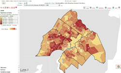 Image courtesy of MPIP
MetroPhilaMapper, a new interactive mapping capacity on MPIP's web site, allows people to explore data from MPIP's annual reports and make their own maps.
|
|
and federal levels to measure conditions and track changes across metropolitan Philadelphia. The project has assembled comparable information for all 353 municipalities included in this region. It then portrays the quality of life in the region's communities, offering analyses of these indicators in occasional web reports and an annual report. All the information from MPIP’s past four annual reports along with hundreds of new indicators is now accessible via this new interactive map. The application is a valuable resource for regional health organizations, arts and culture organizations, social services nonprofits, real estate and planning professionals, and grant makers, as well as families or business owners who may be evaluating greater Philadelphia's communities and economy when choosing where to locate. To explore MPIP’s annual reports and make your own maps, visit the project’s site at www.temple.edu/mpip. |
|